Discover Europe’s diverse landscapes, rich cultural heritage, and unparalleled natural beauty through its remarkable hiking trails. This compilation of the best hikes in Europe offers a selection of trails that cater to every type of adventurer, from strolls through picturesque countryside to challenging treks across rugged mountain terrain.
Featuring trails from all corners of the continent, this list provides a unique opportunity to explore Europe’s hidden gems, iconic landmarks, and breathtaking scenery. Whether you’re a seasoned hiker seeking a thrilling challenge or a casual walker searching for a serene escape, you’ll find the perfect trail to suit your preferences and skill level.
Embark on a journey through the majestic peaks, serene valleys, and captivating coastal landscapes, making Europe’s hiking trails an unforgettable experience for nature lovers and outdoor enthusiasts.
Disclosure: This article features affiliate links, including Amazon.com. If you decide to buy through one of these links, I’ll earn a small commission at no extra expense to you. For more details, please see my disclosure policy.
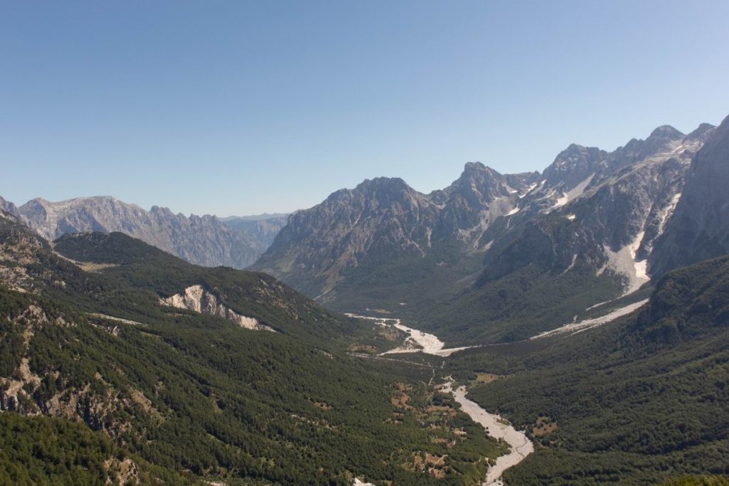
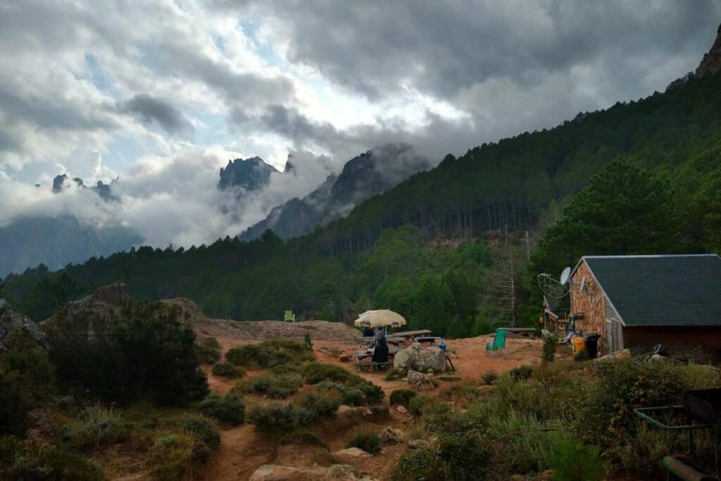
Theth to Valbona hike, Albania
- Location: North-Albania
- Distance: 10 miles / 16 km
- Duration: around 7 hours
- Difficulty: Moderate
The Theth to Valbona hike is a thing to do while backpacking in Albania. It is a breathtaking journey through the heart of the Albanian Alps and is a popular section of the famous Peaks of the Balkans trek. This spectacular hike spans approximately 10 miles (16 kilometers) and takes 6 to 8 hours, depending on the pace and experience.
Throughout the hike, adventurers are greeted with stunning views of lush valleys, crystal-clear rivers, and majestic mountain peaks. The trail is well-marked and traverses through dense forests, steep ridges, and quaint mountain villages. Along the way, you can expect to encounter various species of flora and fauna native to the region and the remnants of ancient stone dwellings.
As a welcome respite, several huts dot the trail, offering refreshing drinks and the opportunity to rest and replenish energy. These huts also provide a chance to interact with locals and fellow hikers, fostering a sense of camaraderie and cultural exchange.
The Theth to Valbona hike is one of the best hikes in Europe. It’s an unforgettable experience showcasing the Balkans’ natural beauty and rich cultural heritage. It is an ideal adventure for avid trekkers and nature enthusiasts seeking to explore the hidden gems of Albania.
Read more: Best hikes in Albania.
Reinebringen hike, Norway
Recommended by Hannah from That Adventurer
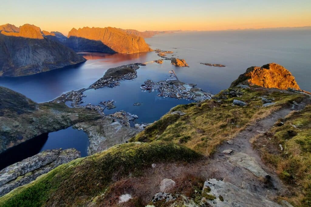
- Location: Reine, Lofoten Islands in Northern Norway
- Distance: 2.1 miles / 3.4 km (but a lot of elevation)
- Duration: 2-3 hours
- Difficulty: Difficult. It’s short but has a lot of elevation, steep, uneven staircases, and some exposure.
The Reinebringen hike is one of the best hikes in Europe and is a beautiful hike with amazing views of the fjords, islands, fishing villages, and mountains that the Lofoten Islands are famous for. This unique combination makes this trail stand out from other European hikes.
The hike is challenging, with steep inclines and rocky terrain, but the views from the top are breathtaking and make it all well worth the effort.
You’ll get views from the moment you start the Reinebringen hike as you walk alongside the road from the parking lot to the trailhead and can gaze up at the mountain you’re about to go and out to the ocean. This is the only section of flat terrain you’ll get, as the Reinebringen trail packs a lot of elevation over a short distance.
You’ll be climbing the sherpa steps, made by sherpas flown in from Nepal, which help prevent trail erosion from the numerous hikers who see the amazing views from the top.
Over 1,500 steps to the top are uneven and slippery in the rain or winter, so hiking this trail during that time is not recommended. You’ll gain elevation fast as you make your way up this stone staircase, and take time to look behind you and enjoy the ocean and mountain views. Along the way, there are some benches and places to pull over and take a much-deserved rest!
You’re in for a treat wherever you take these 360-degree views! The viewpoint at the top of the staircase can get busy, and there’s a steep drop-off, so take care. You can also walk slightly to your left or right if you’re experienced in scrambling to gain a somewhat alternate viewpoint.
Kerry Way, Ireland
Recommended by Janelle Axton from Make the Trip Matter
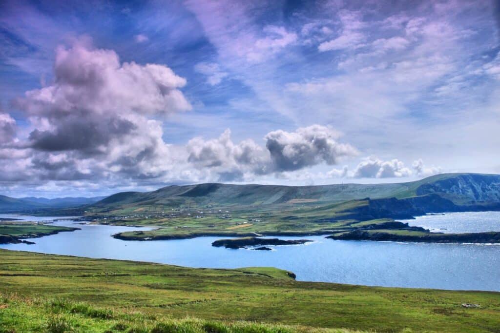
- Location: Kenmare, Ireland
- Distance: 6.4 miles / 10.3 km
- Duration: 3 to 3.5 hours
- Difficulty: Moderate
Hiking from Kenmare to Killarney National Park along the Kerry Way is undoubtedly one of the best hikes in Europe, offering an unparalleled experience of natural beauty, adventure, and culture. This section of The Kerry Way, part of the popular Ring of Kerry, takes hikers through some of Ireland’s most stunning landscapes, providing breathtaking views of the rolling green fields, lush forests, and scenic countryside.
One of the most remarkable features of this hike is its proximity to nature. As hikers make their way through the forested trails, they will be surrounded by a wealth of flora and fauna. The hike is an excellent opportunity to reconnect with nature, away from the hustle and bustle of modern life, providing a perfect escape from the stresses of everyday life.
Moreover, this section of The Kerry Way offers an incredible cultural experience. Starting with the town of Kenmare, hikers can visit traditional Irish pubs, sample local cuisine, and immerse themselves in the area’s rich cultural heritage.
Finally, hikers will be rewarded with some of the most incredible views in Europe. The rolling hills, emerald green fields, and sparkling lakes of the Killarney Forest provide an unforgettable backdrop for the hike. Every step of the way offers new and breathtaking views of the surrounding countryside.
Overall, hiking from Kenmare to Killarney Forest along the Kerry Way is an unforgettable experience that combines nature, culture, and adventure, making it one of the best hikes in Europe. Whether you’re an experienced hiker or just looking to reconnect with nature, this hike is an absolute must-do for anyone visiting Ireland.
Cinque Terre’s Blue Path Trail, Italy
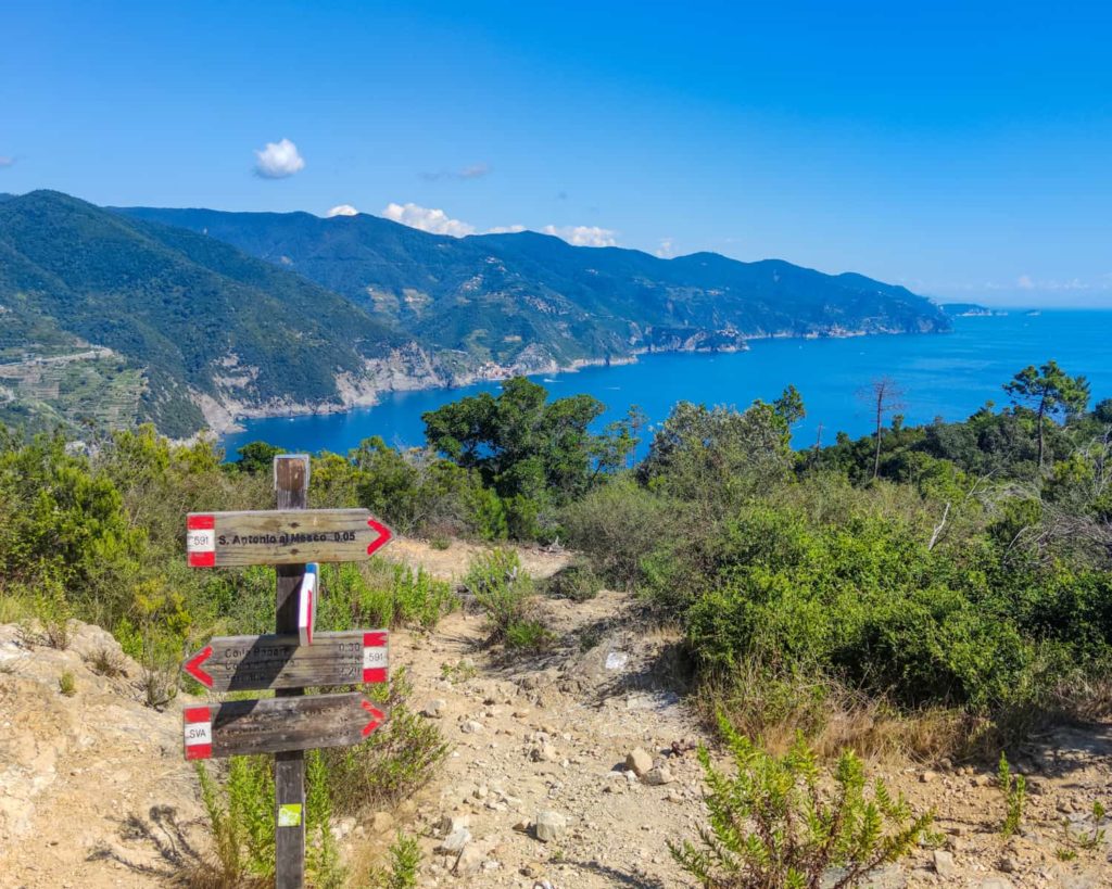
- Location: Cinque Terre, Italy
- Distance: 7.5 miles / 12 km
- Duration: 6 hours on trail
- Difficulty: Easy to Moderate
The Cinque Terre’s Blue Path Trail, also known as Sentiero Azzurro, is one of the most popular hikes in Italy, offering breathtaking views of the Ligurian coast and its charming, colorful villages. This picturesque trail stretches for approximately 7.5 miles (12 kilometers) and connects the five iconic villages of the Cinque Terre: Monterosso al Mare, Vernazza, Corniglia, Manarola, and Riomaggiore.
The Blue Path Trail is divided into four distinct sections, each with a unique character and landscape. You will be treated with panoramic vistas of the sparkling Mediterranean Sea, terraced vineyards, and vibrant hillside towns. Along the way, the trail meanders through lush olive groves, fragrant lemon orchards, and ancient stone paths.
During the hike, you can explore each village, indulge in delicious local cuisine, visit historic churches, and marvel at the distinctive pastel-colored architecture that makes the Cinque Terre so enchanting.
The Blue Path Trail is an unforgettable experience that showcases the natural beauty and cultural heritage of the Cinque Terre, making it a must-visit destination for hiking enthusiasts and travelers seeking to experience the best of Italy’s coastal charm.
Read more: Hiking in Cinque Terre.
GR 221 Mallorca, Spain
Recommended by Adrina Plotzerová from Czech the World
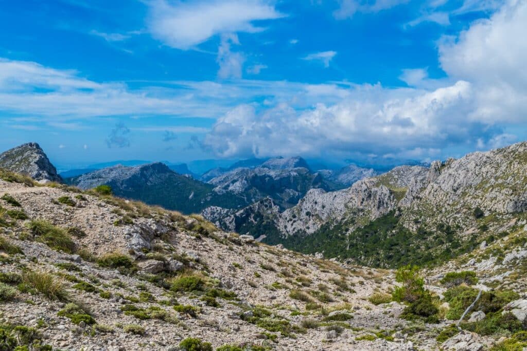
- Location: Serra de Tramuntana, Mallorca, Spain
- Distance: 83.8 miles / 135 km
- Duration: Typically completed in 6-8 days
- Difficulty: Moderate to Difficult
The GR 221, also known as the Dry Stone Route, is a 135-kilometer trail that runs through the Serra de Tramuntana mountain range on the island of Mallorca. The route takes you through some of Spain’s most beautiful and rugged terrains, with stunning views of the Mediterranean Sea and the island’s picturesque villages.
The trail is divided into eight stages, each covering a distance between 11 and 25 kilometers. The route is well-marked, and you can expect to encounter a range of terrains, from rocky mountain paths to forested valleys. Along the way, you will pass through quaint villages and historic towns, where they can stop for a break, shop for food, or to sample the local cuisine.
The best time to hike the GR 221 is in the spring or fall when temperatures are mild, and the crowds are smaller. Hikers should be prepared for some challenging terrain, including steep ascents and descents, but the rewards are more than worth the effort.
When it comes to accommodations, there are plenty of options available along the trail. You can stay in the charming villages of Sóller, Valldemossa, Deià, Esporles, Banyalbufar, Estellencs, Andratx, Port de Sóller, or Port d’Andratx. This makes it easy to plan your itinerary.
In conclusion, the GR 221 in Mallorca is a must-do for any hiking enthusiast looking for an unforgettable adventure in Europe. If you’re considering taking on the GR 221, check out this GR 221 guide with practical tips and a trail map.
Bobotov Kuk hike, Montenegro
Recommended by Anya from Road is Calling
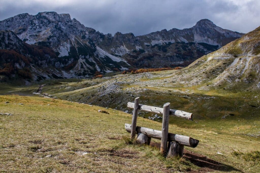
- Location: Durmitor National Park, Montenegro
- Distance: 2.5 miles / 4 km from the trailhead to the peak
- Duration: 6-7 hours, depending on the pace and number of stops
- Difficulty: Moderately Difficult
While there are many amazing hikes in Europe, for me personally, the Bobotov Kuk hike in Montenegro is certainly among the most memorable hikes I’ve been on.
First, it is one of the highest peaks in the Balkans and one of the highest in the Dinaric Alps, a subrange of the more extensive Balkan range. The entire route is very scenic, with panoramic views of rugged mountains and towering peaks of the Durmitor range.
Second, it is also home to various plant and animal species you won’t find anywhere else in Europe. Some of them are Erebia Meolans (a rare species of beautiful brown butterfly with orange spots on its wings) or, for example, Lissotriton Montandoni (a rare salamander species). And yes, you can surely spot them on the path when looking around.
There are four different starting points for this hike, and each of them takes you through the heart of Durmitor National Park (known for Europe’s deepest gorge) and has a different level of difficulty and distance. But the easiest one is only 4 km long one way, offering a variety of landscapes together with unique ecosystems and rare species that can be found only in this part of Europe.
Path of the Gods, Italy
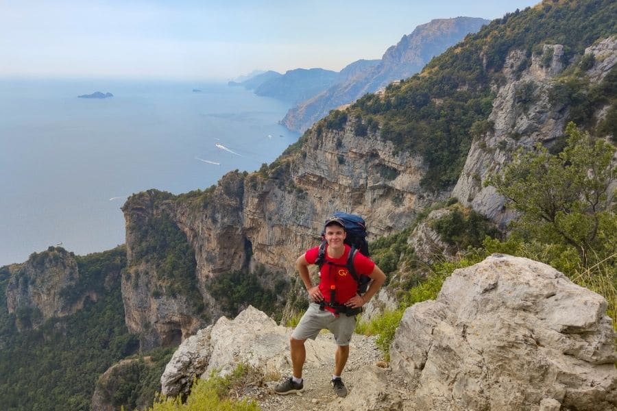
- Location: Amalfi Coast, Italy
- Distance: 5 miles / 8 km
- Duration: around 4 hours
- Difficulty: Moderate
The Path of the Gods is one of the best hikes in Italy that offers an unforgettable experience along the Amalfi Coast. This awe-inspiring trail stretches for approximately 5 miles (8 kilometers) and is situated between the charming coastal towns of Bomerano (in Agerola) and Nocelle, close to the famous Positano.
The trail gets its name from the breathtaking panoramas it offers, providing hikers with a divine experience as they traverse the rugged cliffs and verdant landscapes. Along the way, you will be treated to stunning views of the sparkling Tyrrhenian Sea, terraced vineyards, and charming hillside villages that defy gravity.
During the hike, you will visit historical sites such as ancient stone dwellings and abandoned farmhouses. The trail also features an abundance of vibrant flora and fauna, creating a truly picturesque experience.
The Path of the Gods is one of the best hikes in Europe, where hiking enthusiasts and travelers seek to immerse themselves in the captivating beauty of Italy’s Amalfi Coast. The trail is a testament to the region’s rich cultural heritage and unparalleled natural splendor.
Read more: Best hikes in Amalfi Coast.
West Highland Way, Scotland
Recommended by Maja Proescholdt from Away With Maja
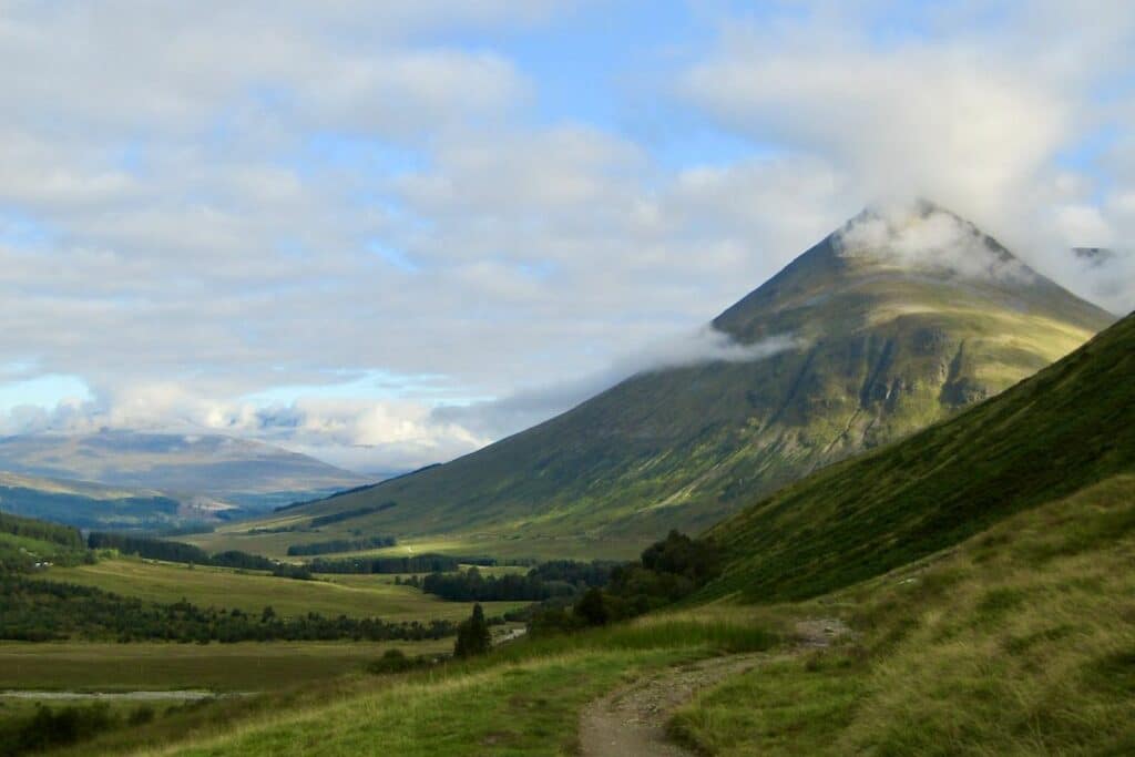
- Location: Scotland
- Distance: 96 miles / 154 km
- Duration: 7 days
- Difficulty: Moderate
The West Highland Way is an incredible hiking trail through the stunning Scottish Highlands. It starts just outside Glasgow, in Milngavie, and finishes in Fort William – most hikers spend 5-7 days on the trail.
While you can do this hike year-round, May to September is the most popular time for the best chance with good weather.
The epic scenery of the Highlands is the real draw here: beautiful lochs, remote moors, and mountainous glens. The West Highland Way goes up Conic Hill and down to the bonnie banks of Loch Lomond before passing the Falls of Falloch, the forest plantations of Crianlarich, and the remote drover’s road through Rannoch Moor to Glencoe.
Hikers are (hopefully) treated to a view of Ben Nevis, the highest mountain in the UK, during the final part of the trail going into Fort William.
The route is very well-signposted – it’s easy to navigate, with regular trail markers. This makes it a top choice for a beginner’s multi-day hiking trail in the UK.
However, you’ll want to be prepared for Scottish weather – you can sometimes experience all four seasons in one day! Waterproof gear, along with dry bags, are essential for this hike.
Some people camp at campsites (or wild camping) along the West Highland Way, or there is plenty of hostel/bunkhouse and B&B accommodation at regular intervals. Take advantage of this fantastic multi-day hike in Scotland! Kingshouse has hotel and bunkhouse accommodations in a desirable location in the heart of Glencoe, right on the trail itself.
Leutkircher Hütte, Austria
Recommended by Greta of Greta’s Travels
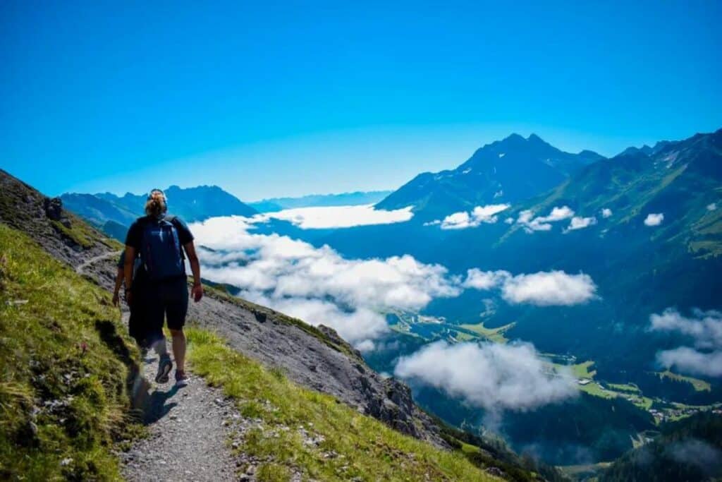
- Location: St Anton, Austria
- Distance: 8.4 miles / 13.5 km
- Duration: 5-6 hours
- Difficulty: Medium-Hard
If you’re looking for the best hikes in Europe, add the trail from Kapall to Leutkircher Hütte and down to St Anton to your bucket list. It’s one of the most scenic mountain trails, with iconic views of the Austrian Alps.
St Anton is a popular winter destination in Austria, famous for its epic ski slopes and fun apres ski. Few travelers visit St Anton in summer, so you should do so!
To start this hike, take two gondolas up to Kapall, at 2,330m. The first 4.1km section of the trail starts, along the mountainside and ridge, with stunning views into the valley and St Anton below. This section has minimal elevation change, going up 190m and down 250m.
After a few hours, you will reach Leutkircher Hütte, where the trail gets its name! This traditional mountain hut is the perfect place for a lunch break. They serve all sorts of local delicacies, including hauswurst with kraut and breadkaspressknodel with sweet kraut. You can eat, rest a bit after the first part of the hike, enjoy the sunshine and views.
The second section of the trail goes from Leutkircher Hütte back down to St Anton. It’s around 9.5km downhill, with an elevation change of 1,000m. It’s quite a challenging slope, but seeing the landscape change as you hike down the mountain is stunning.
You will first hike through clusters of Arlberg trees, the small pine trees from which St Anton takes its name, and then through the bigger pine tree forest and eventually back into town. After this beautiful but challenging hike, you can rest at your hotel! Die Arlbergerin is a great place to stay because it’s close to the trail’s end.
Read more: Best hikes in the Alps
GR20, Corsica
Recommended by Ian of TMBtent
- Location: Corsica (France)
- Distance: 112 miles / 180 km
- Duration: 12 – 16 days
- Difficulty: Difficult
The GR20 is notoriously considered the most challenging hike in Europe, but it is also most certainly one of the best. The route traverses the mountainous interior of the island of Corsica. It features incredible scenery, rustic refuges, and a sense of accomplishment that can only come from hiking this legendary trail.
The route is traditionally hiked from north to south, beginning in the village of Calenzana and finishing in Conca, near the southern tip of the island. Along the way, hikers stay in remote refuges, all offering camping nearby and providing meals and refreshments to hikers.
While difficult, the hike itself is rewarding and features long days on the trail. You’ll find yourself scrambling, taking on steep ascents and descents, and battling the heat that typifies the interior of Corsica. Don’t worry, though, as the rewards of the hike far outweigh the difficulty!
The hiking season for the GR20 begins in June and runs through early October, with the most pleasant temperatures generally occurring in September. It is also possible to only hike a portion of the route, as the village of Vizzavona, which has train connections to the rest of the country, sits at the halfway point.
Those who hike the entire trail should visit the Bar du GR20 in Conca for a ceremonial beer at the finish!
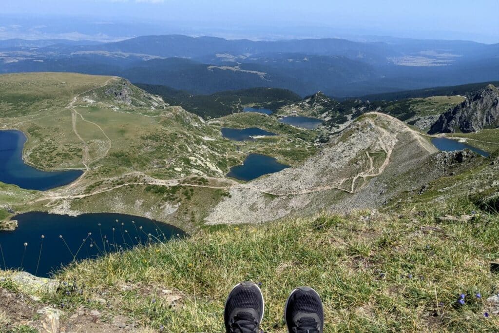
7 Rila Lakes, Bulgaria
Recommended by Carina from bucketlist2life
- Location: Bulgaria
- Distance: 6.2 miles / 10 km
- Duration: 5 hours
- Difficulty: Moderate
The 7 Rila Lakes hike is a great addition to your Bulgaria itinerary. The trail is located in the Rila Mountains near Saparewa Banja and Panichishte. Several mountain huts in the area are a great base. For example, the Pioneer Hut is close to the lift station.
The trek to the Seven Rila Lakes is one of the best experiences in the Balkans. You’ll hike along not one but seven beautiful mountain lakes. The scenery is breathtaking and gets more impressive with each turn and every new lake that comes into view.
The lift doesn’t make this hike effortless, but it does make it more manageable, making it a hike of overall moderate difficulty. Although the maximum distance is only 10 km, you still need to overcome a climb of approximately 600 vertical meters to reach the viewpoint with all seven lakes in a row.
The whole hike takes around 5 hours. If you don’t reach the top, you can turn around earlier and still have amazing views – Kidney Lake is a great place to stop if you want to conserve some energy.
Three things to keep in mind. Firstly, the altitude is around 2000 meters above sea level, so bring warm clothing and don’t do this hike in bad weather. Also, the trail has no shade, and food is only available near the lift. Lastly, if you are okay with drinking from natural springs, you can refill your water bottle during the hike.
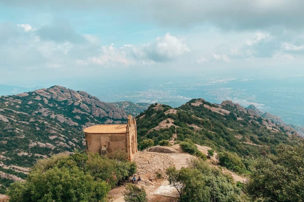
Montserrat hike, Spain
Recommended by Tina from Veganderlust
- Location: Montserrat in Catalonia near Barcelona, Spain
- Distance: 4.3 miles / 7 km
- Duration: about 3 hours
- Difficulty: Easy
Hiking at the Montserrat mountain range is one of the best hikes in Europe, and you can do this scenic hike on a day trip from Barcelona and see stunning views of the Spanish mountains. It’s a short hike since you set off from the famous Montserrat Monastery, which is already 720 meters above sea level. The highest peak of the mountain range is 1,236 meters.
You can make the 3-hour hike even shorter by taking the Sant Joan Funicular and setting off at the end-stop of the funicular. Then the hike will be just around 1-hour return, and you can take the funicular back to the monastery.
Either way, go to the viewing platform at the funicular stop. You can visit the viewing platform even when you don’t have a funicular ticket. From there, you have the best view of Montserrat Monastery from above.
Multiple hiking routes start at the monastery and the funicular end-stop. So make sure to follow the hermitage trail for an easy hike with stunning views.
On the hike, you come past numerous abandoned hermitages and incredible viewpoints. You also get a great view of the Sant Joan Chapel, one of this hike’s highlights. It resembles a small chapel in the middle of a beautiful mountain range.
After the last hermitage, it’s just slightly further to the peak. You get the most amazing views of the Andalusian mountains from the top.
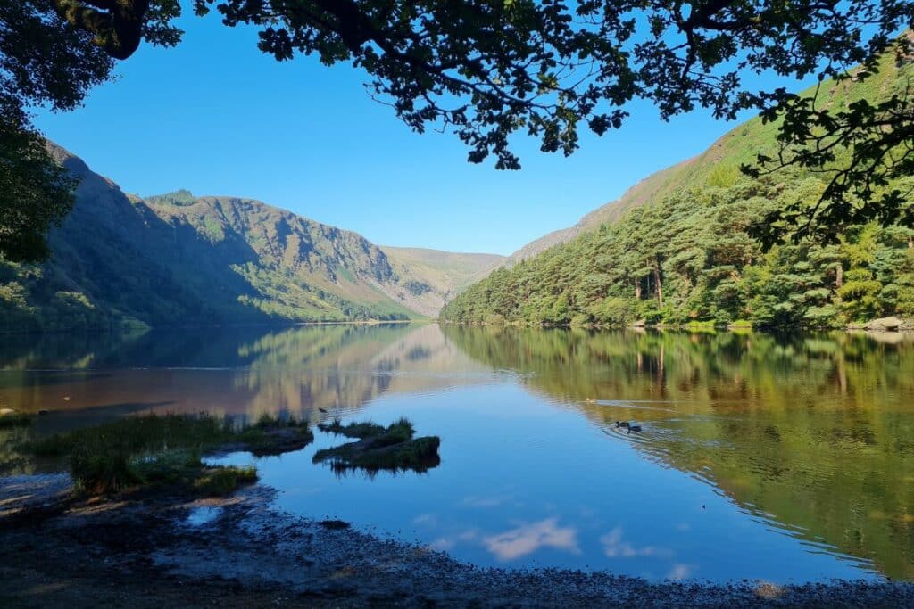
Glendalough Spinc Trail, Ireland
Recommended by Amber from Amber Everywhere
- Location: Glendalough, County Wicklow, Ireland
- Distance: 6 miles / 9.6 km
- Duration: 3 hours
- Difficulty: Moderate
Glendalough is set in the ancient Wicklow Mountains, a glacial lake that has long been surrounded by lore. Lake Glendalough is wonderful and serene, whether you’re viewing it from the shore or from above. The Spinc Trail offers the perfect challenge for hikers and is exceptionally easy to navigate.
The trail takes about 3 hours to complete, and you’ll start with a fairly steep ascent up a mountainside. You’ll pass a waterfall, a good place to take a short break during your climb. A little while further, you’ll emerge from the woods with a view of the lake and the surrounding area.
The next section of the hike takes you along the steep mountainside on wooden planks, offering great views and virtually no chance of losing your way. The trail has incredible views and many lookout points along the way. Finally, you’ll start to wind down, still in full view of the lake.
You’ll pass another small waterfall, the perfect place to stop for lunch or a quick meditation, then continue towards the Miners’ Village, a set of ruins from an old mining encampment. The trail’s end is a leisurely walk through the woods on a wide pathway with lake views from within the trees.
After exploring Glendalough, spend a few minutes soaking in the history and exploring the site. Just a little further up the road is a set of monastic ruins, including several funerary stones and a round tower. After that, find your place to stay in County Wicklow.
Skogafoss Waterfall Trail, Iceland
Recommended by Gretchen from Chasing ADVNTR
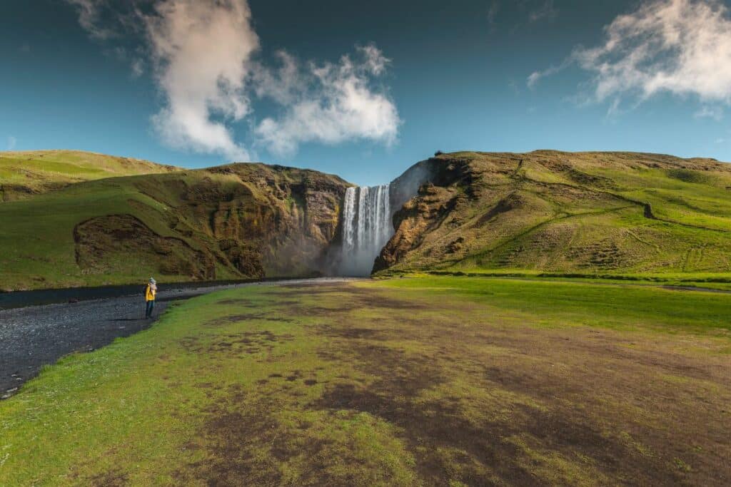
- Location: Southern coast of Iceland
- Distance: Around 5 miles / 8 km
- Duration: 3-6 hours
- Difficulty: Easy to Moderate
The Skogafoss Waterfall Trail (or the lower the Fimmvorduhals Trail) starts at the Skogafoss Waterfall in Southern Iceland and winds up the incredible Skoga river valley. The massive nature landmark is the first scenic waterfall you will see.
Still, as you go up the trail, you will come across several landmarks with incredible sweeping views up and down the valley. The number of waterfalls and the size of each of them along the Skogafoss Waterfall Hike make it one of the best hikes in Europe.
Start the hike by climbing the steps to the right of Skogafoss. From the top of the waterfall, the trail continues alongside the river. Although hiking boots are recommended, the trail is easy to follow and walk.
The Skogafoss Waterfall hike is best done as an out-and-back of about 5 miles, but you can easily make the hike longer or shorter. The entire Fimmvorduhals Trail extends 16 miles into Iceland and can be done as an incredible one-way day hike. If you have a partial day for the hike, many waterfalls are just a short walk above Skogafoss.
Masca Gorge Trail, Tenerife
Recommended by Cristina from My Little World of Travelling
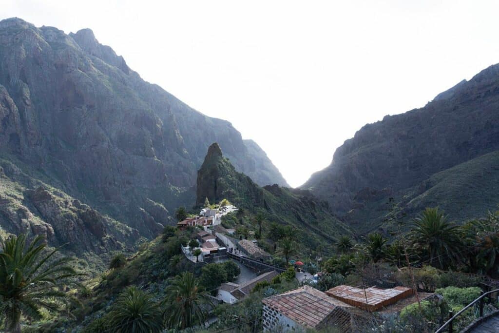
- Location: Masca Gorge Trail in Tenerife
- Distance: 3.1 miles / 5 km (one way). 6.2 miles / 10 km (return journey).
- Duration: About 3h to descend and 4h to ascend.
- Difficulty: Difficult
The Masca Gorge Trail is a popular hiking destination on the island of Tenerife in the Canary Islands, Spain. The trail is known for its stunning natural beauty and challenging terrain that requires moderate to advanced hiking abilities.
There are many reasons why this trail is considered one of the best hikes in Tenerife, and perhaps even in the world, and it’s one of the many reasons to visit Tenerife.
The trail can be challenging, so wearing comfortable shoes and bringing plenty of water is essential. The hike takes approximately 7 hours to complete, and hikers are advised to wear comfortable shoes and bring plenty of water and snacks.
The journey begins in the small village of Masca and takes hikers through a narrow, winding gorge with towering rock formations and lush vegetation. The scenery is breathtaking, and the trail is filled with interesting rock formations, lush greenery, and crystal-clear streams.
The trail ends at the beach of Masca, where hikers can enjoy a refreshing swim in the ocean.
The Masca Gorge Trail is undoubtedly one of the best hiking trails in Europe, and it is easy to see why.
The Masca Gorge Trail is a must-see attraction for nature lovers and adventure seekers visiting Tenerife.
Rysy, Poland
Recommended by Ela & Beata from Stunning Outdoors
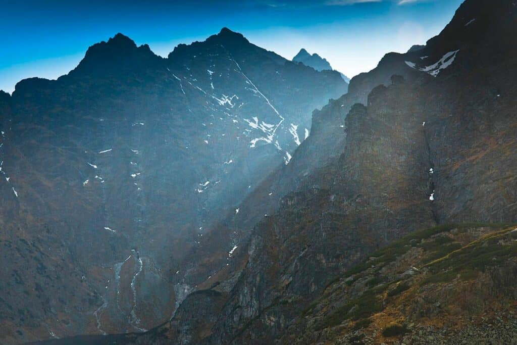
- Location: Tatra Mountains in Poland/Slovakia
- Distance: 15.8 miles / 25.5 km
- Duration: one day
- Difficulty: Difficult, including rock climbing secured with chains
Rysy (2499m) is the highest mountain peak in Poland. Located on the Slovak/Polish border, it can be conquered from both countries.
The route from Zakopane is far more challenging and longer, and as such, should only be attempted by seasoned walkers and people who have some scrambling experience and, most importantly, have a good head for heights.
The approach to the mountain is very long (10 km), requiring getting to the Morskie Oko mountain hut first and then hiking to Czarny Staw Pod Rysami (The Black Pond). The Pond is the last stop before a long climb to the peak.
Morskie Oko and Czarny Staw are fantastic examples of pristine mountain lakes with surrounding tops reflected in their mirror-like waters.
The scramble to the top is long and exposed in places. However, security chains were installed to support climbers. There are no exit/escape routes, and whoever plans to tackle the highest mountain in Poland has to commit.
The 360◦ panoramic view from Rysy is second to none, with stunning mountain oversight to Poland and Slovakia. Hence the one who dares to set foot on this trail will have a day full of adventure packed with breathtaking scenery and an unforgettable experience!
Rysy’s character and alpine terrain mean that the best and only descent route back to Morskie Oko and Zakopane is retracing your steps, but since the very same path and chains are used for climbing up and down, the descent requires the same amount of care, effort and time.
Mt. Rigi hike, Switzerland
Recommended by Diana from Travels in Poland
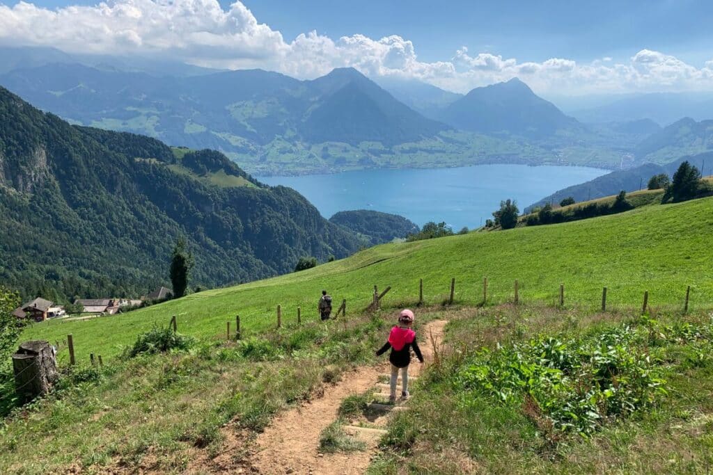
- Location: Mount Rigi Hike, near Lake Lucerne, Switzerland
- Distance: Approximately 5-6 miles / 8-10 km, depending on the chosen route
- Duration: 4-6 hours, depending on the pace and route
- Difficulty: Easy to Moderate
The Mt. Rigi hike near Lake Lucerne in Switzerland offers an unforgettable experience. At the top awaits breathtaking views and a few different hiking trails across the ridges.
The Mount Rigi hike offers a variety of options for hikers, catering to all skill levels and preferences. With well-marked trails and the option to descend via different paths, you can customize your hike to suit your fitness and interests.
There are several options to hike this trail. The best one is to start by taking the Vitznau train up to Mt. Rigi and working your way down the mountain. Alternatively, you can work backward, go up to Mt. Rigi, take the train, or even hike down. If going both ways, starting early in the morning is best, as the total hike will take 12-15 hours.
At the summit, you’ll be rewarded with a panoramic vista of the Swiss Alps and Lake Lucerne.
There are various accommodation options in Küssnacht am Rigi, Lucerne, and nearby towns, including Vitznau, the best town to stay in due to the train heading up.
Preikestolen hike, Norway
Recommended by Steph from A Nomad’s Passport
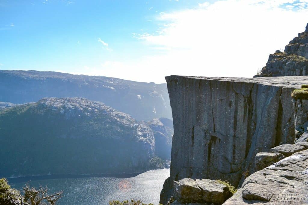
- Location: near Stavanger, Norway
- Distance: 4.7 miles / 7.6 km
- Duration: 4 hours
- Difficulty: Difficult but moderate when compared to other Norwegian hikes
When it comes to epic views and stunning scenery, the Preikestolen Hike in Norway is one of the best hikes in Europe. It starts at a lake, and as you traverse paths and stone stairways installed by sherpas, you pass a variety of environments. Mountain vistas, small lakes you can swim in, marshlands, and a famous fjord view – this hike has it all.
The trail ends at the Preikestolen plateau that towers 604 meters above Lysefjord. Most hikers are happy to spend a reasonable amount of time there before returning to the starting point. Therefore, it is not surprising that it is among the most popular hikes in Norway.
The Preikestolen hike is open year-round, but bear in mind that hiking there in winter requires a high level of experience and crampons. While the most popular time to hike to Preikestolen is from June to August, seeing the fall colors in September and October is an absolute pleasure for your eyes.
It is possible to do it as a day hike (from Stavanger), but you can also wild camp in a flat area not so far away from the famous Preikestolen plateau. This way, you can see sunset and sunrise without hiking in the dark.
Scafell Pike Corridor Route
Recommended by Lauren from The Planet Edit
- Location: The Lake District, England
- Distance: 9.2 miles / 14.8 km
- Duration: 6.5 – 7 hours
- Difficulty: Challenging; there are steep sections, scrambling, and loose scree to contend with.
Sitting 978 meters above sea level, Scafell Pike claims the title of the tallest mountain in England. And as expected of such an accolade, thousands head to the Lake District each year to conquer it.
Several trails will lead you to the summit of Scafell Pike. The most popular by far is the path from Wasdale, as it’s the shortest and easiest of the routes. However, I recommend you take the lesser-known Corridor Route from Seathwaite.
The Scafell Pike Corridor Route may be challenging but undoubtedly the most rewarding and beautiful. It follows an ever-changing landscape of babbling brooks, secluded tarns, striking ravines, and breathtaking valleys on its route to the rocky summit.
This trail begins by following a stream through farmland before ascending past the scenic Styhead Tarn and winding through a series of ravines before making the final push to the summit. The return route runs parallel to a narrow canyon, where years of erosion have carved a series of pretty waterfalls.
The route is also a little more exciting and challenging for the seasoned hiker: you’ll navigate a series of scrambles, including the somewhat infamous “Bad Step”, which is a more challenging scramble that involves clambering 25 feet down the side of the mountain.
The Scafell Pike Corridor Route is a classic English hike showcasing the rugged, tarn-peppered scenery the Lake District is famous for.
Pico de Arieiro, Madiera
Recommended by Abbey from Trips on Abbey Road
- Location: Madiera, Portugal
- Distance: 5 miles / 8 km
- Duration: Around 3-4 Hours
- Difficulty: Difficult
One of the best hikes in Europe is Pico De Arierio on Madiera Island. This changeling hike will take you above the clouds to see this epic island’s most breathtaking panoramic views. The most popular route is the hike from Pico do Arieiro to Pico Ruivo.
You will trek through steep terrain to reach the tallest peak on the island. You’ll pass through forests, deep valleys, and cliffs along the way.
Most people try to arrive at the summit before sunrise to see the sky light up red and orange. This means you will be hiking in the dark and must be extra careful. Bring headlamps because you will need your hands free to climb and move around the steps.
Be sure to bring plenty of water, a few layers, and wear comfortable hiking boots. It’s also good to check the weather forecast before hiking Pico de Areio. The trail can become slippery and dangerous during rainy or foggy conditions. The fog rolls in and out here without much notice. But the vibe that fog creates matches the rugged and unique landscapes.
On clear days, you can see the neighboring island of Porto Santo from the summit. However, you get to experience Pico De Arierio it will be a hike that will stay in your memories forever!
PIN IT
Read more about hiking around the World: